 | An Article from Aaron's Article ArchiveConcrete Arrows in Southwestern Utah Photo: Shinob Kibe PaintbrushIPv4You are not logged in. Click here to log in. |
Use Google to search aarongifford.com:
Here is one of my web log entries, perhaps from my Yakkity Yak page, What's New page, or one of my Astounding Adventures from my Geocaching section: Concrete Arrows in Southwestern Utah
Friday, 11 March 2005 12:16 PM MST
Yakkity Yak, Astounding Adventures
On Concrete Arrows
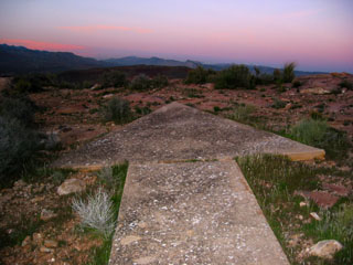
Random Tidbits and Musings on the Historic Aviation Markers in Southwestern Utah While cache hunting (or geocaching), I've come across several large concrete arrows on the ground. At first I wondered what they were for, speculating that perhaps they were aviation markers of some sort. Later, after reading other cache hunters talk about the same arrows, and after reading a historical display in the St. George Utah Municipal Airport about the old Air Mail routes circa 1930, I learned that indeed these were indeed aviation markers, relics left over from aviation history. Apparently Western Air Express was awarded the contract for the Los Angeles to Salt Lake City "contract air mail" route, route number four, or CAM-4, and made their first flight along the 650-mile CAM-4 route in April 1926 in a Douglas M-2 airplane. I don't know when the beacons and arrows were constructed along the route. I have visited three of these arrows so far. I would like to visit more, if more exist. One is located near the Bloomington Overlook cache by Drifty. If you vist that arrow and look where it points, you will see a crooked-topped mesa near Washington, Utah called Shinob Kibe. Another arrow is located near the Shinob Kibe Cache by Astounding (That's me, of course! *smile*) atop that mesa. This particular arrow is airway beacon 37B or HO0622, part of the Los Angeles to Salt Lake City airway route, the "Contract Air Mail" route #4, or "CAM-4" route. If you visit the Shinob Kibe Cache, you can also log your visit to this arrow since it is listed as Airway Beacon Benchmark HO0622. While recently visiting the Shinob Kibe arrow, I wondered if it pointed to the next arrow in the route, and if that next arrow still existed. Sure enough, the next arrow does exist. I used the search as an excuse to place a new cache, the Quail Creek Reservoir West Overlook cache, near the rim of the hill west of Quail Creek Reservoir. I placed the cache before I found the arrow. On the way back to my vehicle, a few hundred feet from where the cache is hidden, I came across the expected arrow.  Arrow above Quail Creek ReservoirBoth the Shinob Kibe and the Quail Creek arrows show evidence that metal towers once stood above the central concrete pads. Also, both of these arrows are approximately 55 to 56 feet in length. I need to revisit the Bloomington Overlook arrow to see how long it is and whether it too shows evidence of a beacon tower. Arrow above Quail Creek ReservoirBoth the Shinob Kibe and the Quail Creek arrows show evidence that metal towers once stood above the central concrete pads. Also, both of these arrows are approximately 55 to 56 feet in length. I need to revisit the Bloomington Overlook arrow to see how long it is and whether it too shows evidence of a beacon tower.
Built at intervals of approximately 10 miles, the standard beacon tower was 51 feet high, topped with a powerful rotating light. Below the rotating light, two course lights pointed forward and back along the airway. The course lights flashed a code to identify the beacon's number.
These arrows in Southwestern Utah aren't quite 70 feet long. Since there is evidence of steel towers on at least two of these arrows, I think there is sufficent evidence that these arrows were a part of this or a similar air route beacon system.
The tower usually stood in the center of a concrete arrow 70 feet long. A generator shed, where required, stood at the "feather" end of the arrow. If there were generators at the Shinob Kibe or Quail Creek arrows, the back concrete pads of both of these are tilted quite a bit (and don't show signs of great cracking or upheaval to indicate that the tilt is due to shifts in the ground), so I wonder how it worked. Also, the only access route to the Shinob Kibe arrow is a narrow, single-file trail, so the concrete, steel, and/or any other equipment or supplies brought to that location would likely have been brought by pack animal, as is mentioned at the same FAA web page. Interesting stuff... | |