 | An Article from Aaron's Article ArchiveFires, Dead Trees, Drains, and Music Photo: April Sun Sets on Shuntavi ButteIPv4You are not logged in. Click here to log in. |
Use Google to search aarongifford.com:
Here is one of my web log entries, perhaps from my Yakkity Yak page, What's New page, or one of my Astounding Adventures from my Geocaching section: Fires, Dead Trees, Drains, and Music
Saturday, 02 August 2003 11:05 PM MDT
Yakkity Yak
Rewind to Thursday, the 31st of July. Early that evening, while at my folks' home in Hurricane, I was going stir-crazy, having been indoors all day in front of a computer. So I badgered my little brother until he admitted a desire to get outside, and we hopped in his car and took off. When he asked where I thought we should go, I told him, "Wherever the car takes us." It took us to Zion National Park, in particular, the Kolob Fingers area of the park, just off of Interstate 15, near New Harmony, Utah.
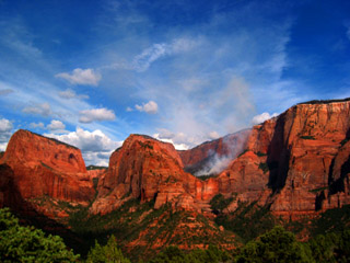
Not long ago, on a trip to Minersville, Utah, my brother and I had noticed a pillar of smoke climbing into the sky from atop one of the towering sandstone mountains of the Kolob Fingers area, Timber Top Mountain, that just peeks over the hills and is briefly visible from the freeway. We both surmised it was from a recent lightning-started blaze. Well sure enough, as the scenic drive rounded the hills to climb southward toward the view point, we had a clear view of smoke rising from a nook, a saddle of sandstone well below the 8,055 ft. elevation summit of Timber Top Mountain.  Smoke rises from the remnant Smoke rises from the remnant
of the Timber Top Mountain fireWhen we reached the scenic view area and parked, before us was a cadre of National Park Service and Forest Service men and women, keeping a careful eye on the fire, ready to react as necessary should the fire do something unexpected. We approached, and asked a myriad of questions about the fire, and learned that yes indeed, a lightning strike had started the fire on top of Timbertop, which had the burned all around the horse-shoe-shaped top of that sandstone mesa, after which the fire had managed to drop vertically down into the saddle below the summit where it was now burning. Another lightning strike had started another fire atop Nagunt Mesa, another nearby sandstone pillar that climbs to 7,785 feet above sea level at its summit, just to the north of Timber Top Mountain. That second fire had done much the same thing, having burned the top of that mesa, then died. Many spruce trees in the area have been killed by the bark beetle, increasing the fire danger that always exists in droughts like this most recent extended one. Looking out at the top of Timber Top, I joked that perhaps it would be now renamed Ash Top Mountain. Like any fire, (and this one was natural, not man-made), not every tree was burned. One of the people we chatted with mentioned having spoken with an older gentleman who remembered a fire atop one of these mesas more than fifty years ago. Since then, the trees on top seemed to recover well. Dispite my sadness at seeing so many trees wiped out in this blaze, I know that time will heal the wound. Speaking of dead trees, my brother and I, this afternoon, drove to Cedar City, Utah, then cruised up the canyon to Cedar Mountain. Wow! What a beautiful place, even despite the massive damage the bark beetle has caused, turning many tracts of spruce forest into standing kindling. In places, the dead trees were a clear majority, with only a sprinkling of seedlings and surviving trees showing green. Nevertheless, I could not help but admire the beauty of this wonderful place. My brother and I drove out through Dry Valley to the incredible scenic overlook near Cascade Falls, where we parked. We hiked the short, but amazingly beautiful 0.47 mile trail along the mountain rim to Cascade Falls. I remember as a teenager hiking this trail with my family. I remember clearly Cascade Falls as a jet of water shooting out of a hole in the side of the cliff. Today, however, instead of a jet of water, a mere trickle flowed forth. The drought was clearly evident! It did offer us the opportunity to peek into the cavern from whence the once mighty jet of water flowed, something that would never have been possible if not for the drought. After a very enjoyable hike back to the car, taking time to examine the conifer trees around the trail, and after a brief exploratory hike along the rim trail in the other direction, we drove to Navajo Lake, a picturesque oblong alpine lake in the bottom of a mountain valley. This lake has no visible outlet. The only outlet is at the valley bottom in the east side of the lake bed, where water disappears into the ground. During wet seasons, the entire valley bottom is covered in water, and the water that escapes the lake's natural drain, flows underground to later show up at Cascade Falls, one of the headwaters of the Virgin River (which then flows into the Colorado River, and eventually into the ocean). Water from the lake also later turns up in Duck Creek, which eventually flows into the Sevier River, a river which empties itself out in the desert of western Utah, never making it to an ocean anywhere. In 1931, a dike was built across the valley to keep water in the lake even during dry years like this year. In wet seasons, the lake covers the dike completely. In dry years, the eastern end of the lake drains away, leaving the valley floor exposed. We arrived at the lake and parked near the dike, then walked down out of the surrounding forest and on to the dry lake bed. We walked across to a tiny ravine where a trickle of water that managed to seep through the dike meandered across the valley floor, toward the lake's natural drain. I'd always been curious about the lake's outlet, so we decided to follow the tiny ravine to see where Navajo Lake's drain was located. Not far away, the trickle of water disappeard into the cracks between a jumble of basalt rocks. We'd found the lake's drain! We paused and listened to the sound of the water spilling into the earth's orifice. We'd just seen where the water exited the bowels of the earth, and here was where it entered. For the fun of it we walked the rest of the way across the valley floor, turned to the lake shore, skipped some rocks on the water's surface, then returned to the car across the dike, passing many hopeful fishermen, fisherwomen, and fisherchildren on our way. I had a wonderful time in a very beautiful place. And I'd had the chance to do some hiking and walking today. Every time we do such things, we mention to on another how we should do things like that more often. Did I mention that I recently upgraded my music software on my computer? I upgraded from Cakewalk's old Cakewalk software, to their new Sonar tool set. I also added some other stuff. I'm in auditory heaven, with software synthesizers now at my fingertips, and I'm no longer subject to whatever voices my computer's sound card can come up with. For good measure (pun intended), I dredged up one of my old 1996 MIDI shorts (short compositions - this one is about a minute in length) and used one of Sonar's DXi synthesizers to turn it into an MP3 audio file. You can hear it here. I'm still in Hurricane, but I'd better quit typing and drive home to St. George. It's late! And my sister's kitten keeps trying to jump onto the keyboard and capture the blinking cursor or the mouse pointer. | |