 | An Article from Aaron's Article ArchiveMy Brother Gets a G.P.S. and the Return of the Cachemobile Photo: Sand in BloomIPv4You are not logged in. Click here to log in. |
Use Google to search aarongifford.com:
Here is one of my web log entries, perhaps from my Yakkity Yak page, What's New page, or one of my Astounding Adventures from my Geocaching section: My Brother Gets a G.P.S. and the Return of the Cachemobile
Saturday, 27 March 2004 6:00 PM MST
Astounding Adventures
Cache Visited: Trail of the Padres? by k-9kween
Saturday, 27 March 2004 - Late Afternoon, perhaps 5:00 or 6:00 PM MST (-0600)  Parked at the base of the hill, we noticed this trail winding up the hillside.Congratulations, Percible! (That's my brother's Geocaching nickname.) Parked at the base of the hill, we noticed this trail winding up the hillside.Congratulations, Percible! (That's my brother's Geocaching nickname.)
For my brother's birthday this year, my family got together and pooled our resources to buy him a new Garmin eTrex Vista G.P.S. receiver. I think he likes it. So of course we had to try it out before the sun went down. Also, my formerly trustworthy cachemobile, my Chevy S-10 Blazer 4x4, after months sitting idle, unused, and broken since August, is now back in business, repaired and road-worthy once again. While I love my new Hyundai Sonata, I just can't take it cache hunting out in dirt-road country in Southern Utah. So of course we had to not only try out my brother's GPS, but give my old cachemobile a chance to taste the dust from a dirt road on the way to a stash. Though we started late in the afternoon, there was an excellent virtual cache to meet our needs, just south of Hurricane, Utah where we were. From the description, we knew we'd hit at least a little bit of dirt road, and we'd have a bit of hiking to do. That's exactly what the doctor ordered.  Late winter rains were evident in the abundant (for a desert) green foliage all over the hill.Off we sped, winding our way south through the Hurricane fields, then past Sky Ranch, then into the dirt, Percible doing the navigating with his pristine eTrex in hand. Even with the cache description and a trusty G.P.S. we took a wrong turn or two and had to backtrack, but it wasn't long before we had arrived at the base of a hill, the G.P.S. pointing to the top. Late winter rains were evident in the abundant (for a desert) green foliage all over the hill.Off we sped, winding our way south through the Hurricane fields, then past Sky Ranch, then into the dirt, Percible doing the navigating with his pristine eTrex in hand. Even with the cache description and a trusty G.P.S. we took a wrong turn or two and had to backtrack, but it wasn't long before we had arrived at the base of a hill, the G.P.S. pointing to the top.
We found a trail that began to wind its way up the hillside, and followed, even though it didn't go directly toward the cache location, trusting that it would be an easier route than bushwhacking straight up the steep hillside. That was a good move, since I'm out-of-shape, having slacked off on the cache hunting business for a bit.  We found the cache!The air was perfect for a hike up a hill, cool, with a gentle breeze. The sun was slowly sinking toward the horizon, and the long afternoon light brought out the colors around us. The moisture from the rain in early March meant the basalt-bespeckled desert hillside was alive with little green things growing here and there. It was beautiful. We found the cache!The air was perfect for a hike up a hill, cool, with a gentle breeze. The sun was slowly sinking toward the horizon, and the long afternoon light brought out the colors around us. The moisture from the rain in early March meant the basalt-bespeckled desert hillside was alive with little green things growing here and there. It was beautiful.
 Looking down at Sky Ranch below us in the valley to the north from the cache site.Once mostly atop the hill, the navigator with his new G.P.S. informed me that the cache was off to our right, almost ninety-degrees from where the trail was taking us. It was time to leave it behind. We bid it farewell and went west as all young men should. Looking down at Sky Ranch below us in the valley to the north from the cache site.Once mostly atop the hill, the navigator with his new G.P.S. informed me that the cache was off to our right, almost ninety-degrees from where the trail was taking us. It was time to leave it behind. We bid it farewell and went west as all young men should.
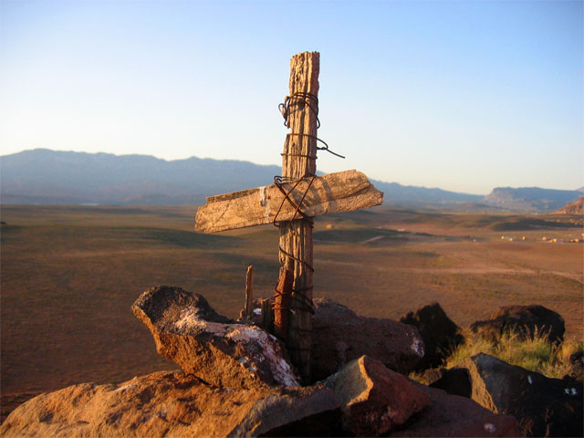
 Dust trails rise behind vehicles scurrying across the desert floor below us.We crested the ridge, then began descending gently toward the edge where the hill broke off to sharply descend into the sandy basin below. There, ahead of us, was a stone cairn, with what looked like a rough wooden cross atop it. That had to be the cache! Dust trails rise behind vehicles scurrying across the desert floor below us.We crested the ridge, then began descending gently toward the edge where the hill broke off to sharply descend into the sandy basin below. There, ahead of us, was a stone cairn, with what looked like a rough wooden cross atop it. That had to be the cache!
Of course it was, a marker in the Dominguez-Escalante trail. Good job, k-9kween! My brother even discovered the pamphlet in a crevice of the rocks.  My brother's brand-new G.P.S. led us to the cache site.Since I'd borrowed our mother's digital camera, I went snap-happy, taking snapshots here and there and everywhere as the sun drooped lower and lower. My brother's brand-new G.P.S. led us to the cache site.Since I'd borrowed our mother's digital camera, I went snap-happy, taking snapshots here and there and everywhere as the sun drooped lower and lower.
Below us, dust trails rose behind vehicles, some four-wheelers, a jeep, and one or two others. It was fun to watch from high above.  The Hurricane Cliffs to the northeast were painted by last rays of the setting sun.We took a direct route back to my vehicle, charging down the hill, pausing only so I could snap more pictures as the sun finally set. The Hurricane Cliffs to the northeast were painted by last rays of the setting sun.We took a direct route back to my vehicle, charging down the hill, pausing only so I could snap more pictures as the sun finally set.
Oh, yeah, I went a little crazy trying to take a macro shot of a large ant guarding the entrance to an ant nest, too. And when we continued our descent, I left the camera case on the ground, forgotten. Several hundred yards down the slope, I realized it was missing, so we had to retrace our steps until I found it.  The sun sets over Sand Mountain, sinking behind the hills to the west.It's always a little unnerving when a cell phone call comes when you're out in the middle of nowhere. My brother's friend and fellow cache hunter had tracked him down at my cell number, so I passed my phone to my brother, and we continued down the hill. The sun sets over Sand Mountain, sinking behind the hills to the west.It's always a little unnerving when a cell phone call comes when you're out in the middle of nowhere. My brother's friend and fellow cache hunter had tracked him down at my cell number, so I passed my phone to my brother, and we continued down the hill.
What a fun little hike, and a fun and historic cache to find! Thanks again, k-9kween! -Astounding St. George, Utah | |